Machine Learning Improves Satellite Rainfall Estimates
A new deep learning approach bridges ground rain gauge and radar data with spaceborne radar observations of Tropical Rainfall Measuring Mission to improve precipitation estimation.
SOURCE: Geophysical Research Letters

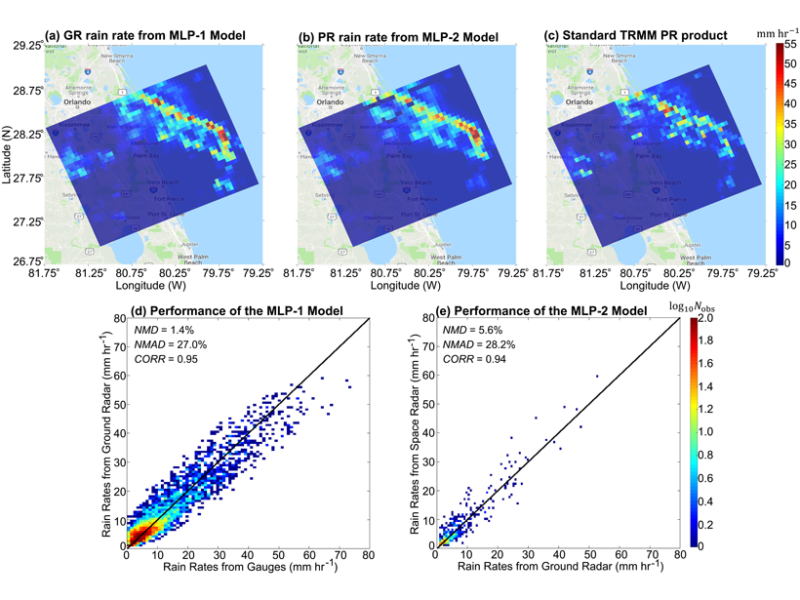
An illustration of rainfall estimates from ground-based radar and spaceborne Tropical Rainfall Measuring Mission (TRMM) radar on 20 May 2009. (a) Ground radar rainfall estimates obtained with a machine learning approach trained with ground rain gauge data; (b) space radar estimates obtained with a machine learning model trained using ground radar estimates; and (c) standard TRMM product. An assessment of machine learning approach performance using hourly validation data for 2009 shows (d) ground radar rainfall estimates versus rain gauge data and (e) TRMM rainfall estimates versus ground radar product. Credit: Chen et al. [2019], Figure 2
Spaceborne precipitation observing systems can provide global coverage but estimates typically suffer from uncertainties and biases. Conversely, ground based systems such as rain gauges and precipitation radar have higher accuracy but only limited spatial coverage. Chen et al. [2019] have developed a novel deep learning algorithm designed to construct a hybrid rainfall estimation system, where the ground radar is used to bridge the scale gaps between (accurate) rain gauge measurements and (less accurate) satellite observations.
Such a non-parametric deep learning technique shows the potential for regional and global rainfall mapping and can also be expanded as a data fusion platform through incorporation of additional precipitation estimates such as outputs of numerical weather prediction models.
Citation: Chen, H., Chandrasekar, V., Tan, H., & Cifelli, R. [2019]. Rainfall estimation from ground radar and TRMM Precipitation Radar using hybrid deep neural networks. Geophysical Research Letters, 46. https://doi.org/10.1029/2019GL084771
—Valeriy Ivanov, Editor, Geophysical Research Letters
AGU发布最新国外工作学习机会
1.PhD Assistantship in Disease Spread Modeling at NC State University
Raleigh, North Carolina (US)
$25,000/year + tuition and health insurance
Center for Geospatial Analytics
2.Graduate Assistantships in Remote Sensing, GIS, Ecological and Water Resources Engineering, SUNY ESF
Syracuse, New York
State University of New York College of Environmental Science and Forestry
https://findajob.agu.org/job/8011326/graduate-assistantships-in-remote-sensing-gis-ecological-and-water-resources-engineering-suny-esf/
3.Funded PhDs in Paleoclimate Modeling at the University of Connecticut
University of Connecticut at Storrs, CT
Department of Geosciences - University of Connecticut
The Computational Climate Change Lab at the University of Connecticut seeks applicants for funded PhD positions in paleoclimate modeling.
4.Post Doctoral Researcher
Berkeley, California (US)
Salary will be predetermined based on postdoctoral step rates.
Lawrence Berkeley National Laboratory
https://findajob.agu.org/job/8011482/post-doctoral-researcher-/
5.HBOI Postdoctoral Fellow Coupled Physical-biogeochemical Modeling of Harmful Algal Blooms
Fort Pierce, Florida
Commensurate with experience
Florida Atlantic University
Florida Atlantic University is seeking a HBOI Postdoctoral Fellow Coupled Physical-biogeochemical Modeling of Harmful Algal Blooms, Fort Pierce, FL.This position is located at FAU’s Harbor Branch campus in Fort Pierce,FL.


